Wildfires are critical natural hazards, both in the Mediterranean and boreal regions of Europe, causing significant environmental and economic damages and losses. Operational drought and fire risk forecast services on sub-seasonal, seasonal and climatic scale allow fire protection authorities to increase preparedness and response in drought and fire related emergencies and to develop mitigation and adaptation strategies in these regions.
ANDREA VAJDA1, CECILIA WOLFF1, OTTO HYVÄRINEN1, MASSIMILIANO PASQUI2, VASSILIKI VARELA3, PETER VAN VELTHOVEN4, FOLMER KRIKKEN 4, MONICA PROTO5, ROSA LASAPONARA5
1Finnish Meteorological Institute
2Italian National Research Council – Institute for the BioEconomy
3National Centre for Scientific Research ”Demokritos”
4The Royal Netherlands Meteorological Institute
5Italian National Research Council – Institute of Methodologies for Environmental Analysis
The ERA4CS SERV_FORFIRE project aims to develop operational services for fire assessment, monitoring and mitigation strategies from seasonal up to climatic time scale for different ecosystems and geographic areas ranging from Southern to Northern Europe. The tailored drought, fire and post-fire products have been implemented with the involvement of users, i.e. national and local authorities and decision makers in order to increase the user uptake and improve the preparedness level and efficiency of fire authorities in risk management. The usefulness of the developed services was demonstrated through applications both in Southern and Northern Europe. Four of the implemented and demonstrated drought and fire risk forecasting products and their related case studies are introduced in this paper. The selected case studies cover various time scales ranging from sub-seasonal to seasonal and climatic scale, all of them providing essential information on the meteorological conditions triggering wildfires in the present and future climate.
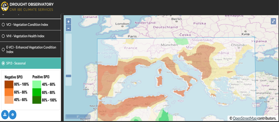
Southern Europe and the Mediterranean basin are considered possible hot spots for drought and its consequences for fire risk and water security (Prudhomme et al. 2014). To reduce the temporal gap existing between the drought onset and development, and the response in managing the related emergencies, the Italian National Research Council developed a seasonal forecasting system for drought for the Mediterranean basin to provide a semi-automatic, timely and comprehensive operational service for decision making, water authorities, researchers and stakeholders (Fig. 1). The seasonal forecasting component of the system is based on an empirical approach that predicts meteorological drought up to three months in advance using the standardized precipitation index, from large-scale observed climate indices. This empirical system adopts a physically based statistical approach which uses a multivariate regression model to estimate future anomalies. Predictors are selected from observed atmospheric (Seasonally Varying NH Annular Mode, Arctic Oscillation, North Atlantic Oscillation, and Modified zonal index) and oceanic sea surface anomaly patterns (Atlantic Multidecadal Oscillation, Multivariate ENSO Index among others) as described in details in Magno et al. 2018.
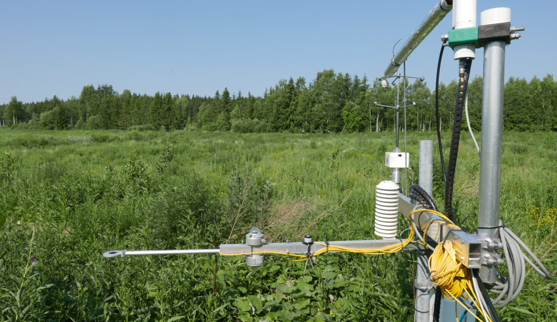
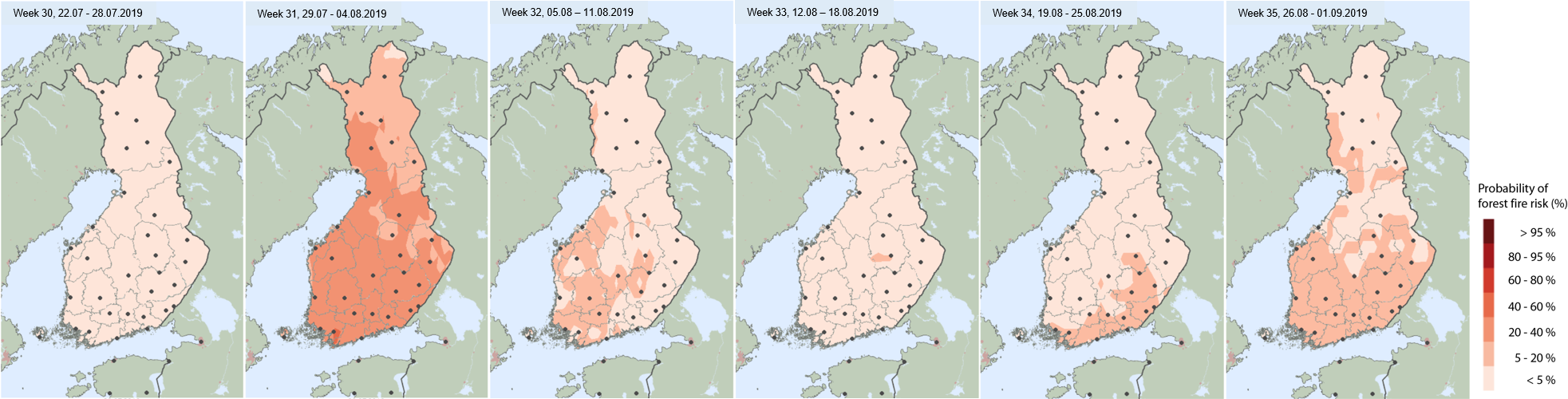
To extend the fire warning services run by the Finnish Meteorological Institute, a novel six-week forest fire danger outlook prototype was developed and piloted with Finnish end-users, i.e. the Regional State Administrative Agency (AVI) from Northern Finland and the Finnish Rescue Services from North Karelia during the fire season 2019. The sub-seasonal fire forecast product would complement the already existing forest fire risk monitoring system and the regularly issued short-range forest fire warnings. To predict the probability of sub-seasonal fire danger a statistical model originating from the Finnish Forest Fire Index (FFI) was developed and tested (Wolff et al. 2019). The Finnish Forest Fire Index (FFI) is determined by estimating the volumetric moisture of a 60 mm thick surface layer (Vajda et al. 2014) and it is already used by FMI in the operational fire monitoring and warning system. The six-week forest fire outlooks (Fig. 2) were produced using as input the ECMWF EPS system data and observed daily FFI values to spin-up the index and delivered to the users twice a week through an operational service. According to the feedback received from the end-users, the outlooks were very useful when planning in advance the fire survey flights. The product is further improved and iterated again with the users during the fire season 2020.
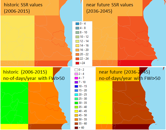
Eastern Attika (Greece), is a wildland-urban interface area frequently affected by forest fires. Fire risk estimation for the area and its change in the future was performed by the National Centre for Scientific Research ”Demokritos” computing and mapping the Canadian FWI system components (Van Vagner 1987) on a daily basis during the fire seasons (May-October) for ten years, for the past (2006-2015) and near future (2036-2045) climate. The Canadian Fire Weather Index (FWI) represents the potential fire line intensity and it is a good indicator of general fire danger. The Daily Severity Rating (DSR), calculated as an exponential function of FWI, is a numeric rating of the difficulty of controlling fires, whereas Seasonal Severity Rating (SSR) is the averaged DSR during a fire season. These FWI components and their maps (Fig. 3) were produced using an ensemble of two high resolution (12.5 km) EURO-CORDEX regional climate models with medium emission scenario (RCP4.5).
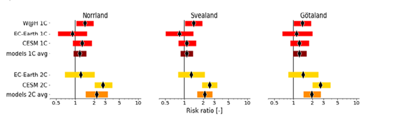
In the summer of 2018 forest fires raged through large parts of Sweden. To answer the question to what extent climate change has influenced such extreme event a climate attribution analysis was performed by The Royal Netherlands Meteorological Institute by studying the Canadian FWI in multiple observational and climate datasets. Analysis showed that the maximum FWI in July 2018 had return times of ∼24 years. The climate models pointed to a ∼10% increased risk for such events in the current climate relative to pre-industrial climate. For the future climate (2°C warming) a roughly 2 times increased risk for such events relative to pre-industrial climate was found, which is mainly attributed to the increase in temperature. In summary, a small but positive role of global warming up to now in the 2018 forest fires in Sweden, but a more robust increase in the risk for such events in the future was found (Fig. 4).
The climate services implemented and demonstrated through the presented case studies provide science-based, useful tools for end-users and decision makers in the fire-prone regions facilitating their preparedness and development of adaptation strategies on various timescales.
Acknowledgements: The study contributes to the ERA4CS SERF_FORFIRE project (grant 690462), an ERA-NET initiated by JPI Climate with co-funding from the European Union.
References
Magno, R., et al., 2018: Semi-automatic operational service for drought monitoring and forecasting in the Tuscany region, Geosciences, 8(2), 49, DOI: https://doi.org/10.3390/geosciences8020049
Prudhomme, C., et al., 2014: Hydrological droughts in the 21st century, hotspots and uncertainties from a global multimodel ensemble experiment, Proceedings of the National Academy of Sciences, 111(9), 3262-3267
Vajda A., et al., 2014: Assessment of forest fire danger in a boreal forest environment: description and evaluation of the operational system applied in Finland, Meteorological Applications, 21(4), 879–887, DOI: https://doi.org/10.1002/met.1425
Van Wagner, C. 1987: Development and Structure of the Canadian Forest Fire Weather Index System, Technical Report 35, Canadian Forestry Service, Ottawa, Ontario.
Wolff C., Vajda A., and Hyvärinen O., 2019: Developing a model for forest fire risk forecast at sub-seasonal scale in Finland, FMI’s Climate Bulletin: Research Letters, 1(2), 6, DOI: https://doi.org/10.35614/ISSN-2341-6408-IK-2019-15-RL
HOW TO CITE THIS ARTICLE:
Vajda A., Wolff C., Hyvärinen O., Pasqui M., Varela V., Van Velthoven P., Krikken F., Proto M., and Lasaponara R., 2020: Climate services for drought and fire danger estimation on various time scales, FMI’s Climate Bulletin: Research Letters, 2(1), 14–16, DOI: https://doi.org/10.35614/ISSN-2341-6408-IK-2020-06-RL
CITATION INFORMATION:
Authors: Andrea Vajda, Cecilia Wolff, Otto Hyvärinen, Massimiliano Pasqui, Vassiliki Varela, Peter Van Velthoven, Folmer Krikken, Monica Proto, and Rosa Lasaponara
Received: March 2, 2020
Accepted: May 11, 2020
First online: May 15, 2020
Published: May 25, 2020
Journal: FMI’s Climate Bulletin: Research Letters
Volume: 2
Issue: 1
Pages: 14–16
DOI: https://doi.org/10.35614/ISSN-2341-6408-IK-2020-06-RL
This article is part of the ERA4CS Special Issue.
Header image: Pixabay