The Finnish Meteorological Institute has developed Harvester Seasons, a web-based service for the forestry sector aiming to pave the way for climate smart operations. This service is supporting the forestry sector by offering a dedicated trafficability and soil information service based on weather and seasonal forecast models. This service leverages the European efforts on climate monitoring by linking Copernicus DIAS platforms, the Copernicus Climate Data Store, and Copernicus seasonal forecasts with climate data records.
MIRIAM KOSMALE1, JAAKKO IKONEN1, MIKKO MOISANDER1, TUOMO SMOLANDER1, HEIKKI OVASKAINEN2, ASKO POIKELA2, MIKKO STRAHLENDORFF1
1Finnish Meteorological Institute
2Metsäteho Oy
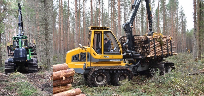
Background. The Finnish forestry sector traditionally plays a significant role for the national economy. More than 75 % of Finland is covered with forests, which leads to the wood production being responsible for 1/5 of Finland’s export market. Approximately 2.7 billion euros from the forestry sector is an important part of Finland’s annual tax revenue (Finnish Forest Industries 2021). Commercial timber harvesting in Finland takes place mechanically with wheel-based forest machines. The machines used by forest machine contractors and operators need good load-bearing conditions for their operations due to their heavy weight. A typical harvester chain consists of a harvester and a forwarder, of which the forwarder can weigh almost 40 tons when fully loaded (Fig. 1).
According to the Finnish Forest Act on forestry, wild species, and ecosystems, the “damage to the terrain which may weaken the growing conditions for the tree stand must … be avoided” (Ministry of Agriculture and Forestry 2014). Especially the number of deep ruts greater than 10 cm caused by heavy machinery has to be kept minimal. On surfaces with low soil bearing capacity, heavy harvesting machines can cause damage and prevent adequate regeneration of the ground.
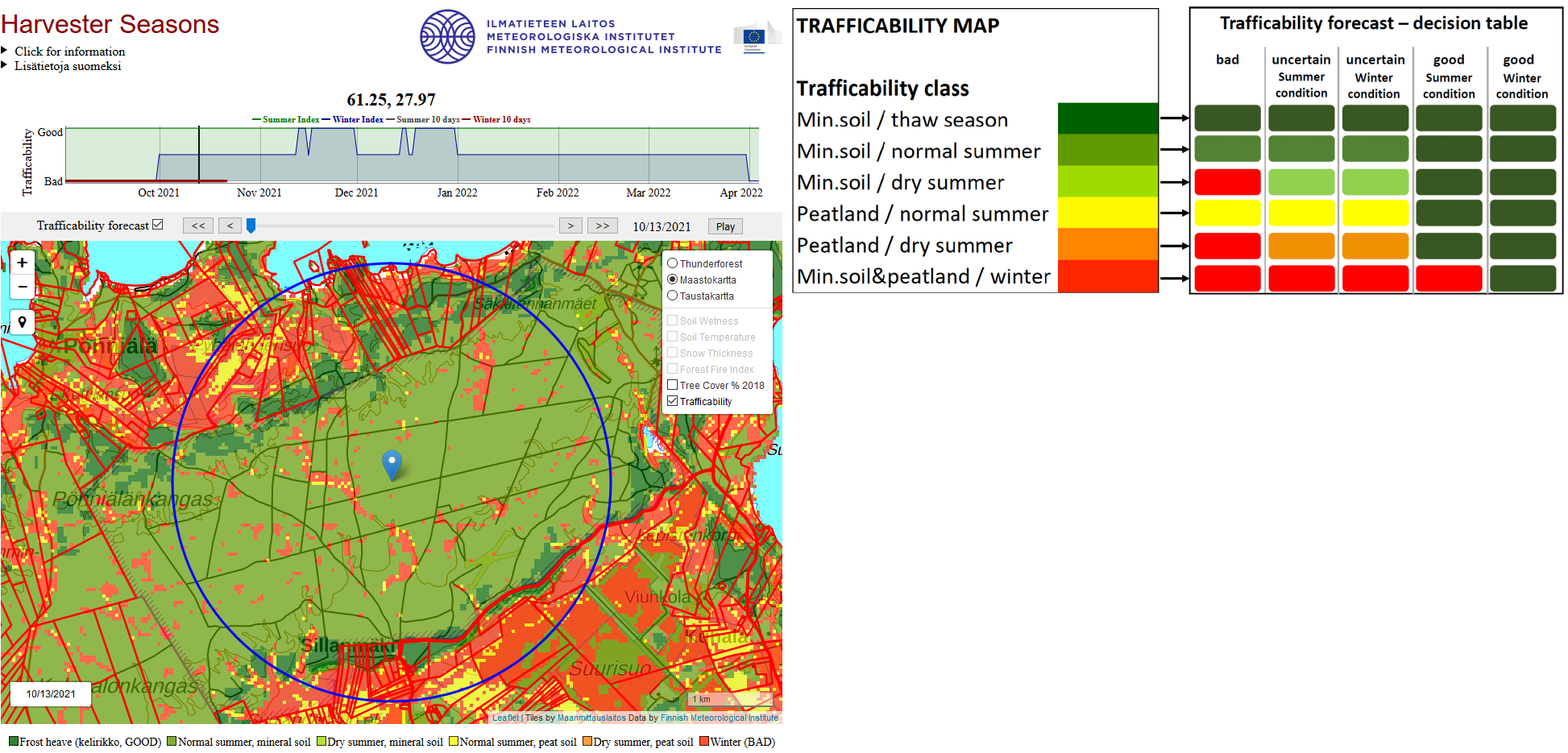
Finnish forest can be classified into areas of good harvestability, depending on annual season, weather condition and soil condition. Based on ALS Airborne Laser Scanning via LIDAR measurements and a digital elevation model, Metsäkeskus (Finnish Forest Centre) is providing static trafficability mosaics for Finland (Metsäkeskus, 2021). Those maps are differentiating between mineral soil and peatlands and classifying whether those surfaces have sufficient soil bearing capacity. Classes are color-coded from green to red, thus representing the trafficability on different soil conditions (Fig. 2, right) and seasons. In Finland, the share of peatlands from which wood can be harvested only in winter is relatively high. Within the recent years good winters for harvesting have decreased. Warmer winter like in 2019/2020 (Lehtonen 2021) made it necessary to adapt harvesting operation planning. The challenge in timber harvesting is to optimize the operation planning according to actual carrying capacity of the ground to avoid significant shortfalls in production. Smart operation planning does not only have monetary effect but also help protecting our forest environment and ecosystem.
Harvester Seasons (https://harvesterseasons.com) is a web application developed by the Finnish Meteorological Institute that supports the Finnish forestry sector by offering dedicated trafficability and soil information system.
Copernicus, the backbone for Harvester Seasons. Copernicus, Europe’s eyes on Earth, offers access to global and local data from satellites, ground-based measurements, or model data. Harvester Seasons input data stream is built upon this backbone of Copernicus data.
Copernicus Climate Change Service (C3S), implemented by ECMWF, produces monthly updates of daily seasonal weather forecasts for 6 months ahead (Copernicus 2021a) as well as grid-based reanalysis data by ERA5-Land (Muñoz Sabater 2019). By bias-adjusting this seasonal weather forecast with higher resolved climate statistics of ERA5-Land, it is possible to ingest 51 highly resolved ensemble forecasts into the Harvester Seasons service backend. Trafficability information is then derived by combining statistically model forecasts of soil parameters and seasonal forecast data with the lidar based static surface classification datasets. For the short-term forecast FMI’s 10-day weather forecast information is used for service prediction of trafficability. In collaboration with the experts from the forestry sector and based on works of Sirén et al. (2019) and Bergqvist et al. (2018), thresholds for hydrological and meteorological conditions were set in order to derive a dynamic classification (Fig. 2, right). Even though long-term seasonal forecasts up to half a year are still challenging (Hyvärinen et al. 2020), the approach of dynamic trafficability indices helps the forestry sector in climate smart operation planning.
Harvester Seasons on WEkEO DIAS. WEkEO is one of the 5 EU Copernicus DIAS reference services for environmental data, virtual processing environments and skilled user support (Copernicus 2021b). WEkEO has direct access to the Climate Data Store, which leverage C3S data for Harvester Seasons. Backend and frontend of the Harvester Seasons service is completely implemented within the WEkEO virtual machines.
Co-design and user feedback. Within the funding frameworks of Copernicus Programme’s Climate Change Service (C3S) as well as the e-shape project, the primary focus of this service is on direct user interaction. As co-design partners FMI had Metsäteho and with its customers and clients, direct access to feedback from the forestry sector. Metsäteho’s shareholders are all large Finnish forest companies (Metsä Group, Stora Enso, UPM) and state forests (Metsähallitus), for which private harvesting contractors offer harvesting services.
Service developers implemented user requirements iteratively. These requirements were, e.g., an easily understandable map layer, index-based trafficability information (good vs bad) and the necessity of direct API access for user interfaces. Color-coding for the dynamic weather dependent trafficability has been established in a similar way to the already existing static trafficability maps. This helps users to easily grasp the new service information by its well-established look (Fig. 2). Foremen of harvesting machines as well as operation planners require condensed information for it to have a real added value for their daily work.
As a special request by stakeholders, selected land cover characteristics (Copernicus 2021c) like tree cover density and FMI’s forest fire index are included in the service. Harvesting operations with machines equipped with steel tracks increases the risk for light fires within forests. In Finland authorities give warnings during high forest fire risk and harvesting operation activities should be suspended. The forest fire warning system is designed to inform the general public and the fire authorities about forest fire risk caused by dry terrain (Vajda et al. 2014).
Summary. The Harvester Seasons service has been launched for a greater Finland domain in May 2020. The web application is focusing on trafficability to support planning of harvesting operation and fostering Earth Observation and model prediction data in business operations. Having direct access to Copernicus climate data records and having them translated to a tailored information content bridges the gap between science and community.
Service Info. The service is accessible at https://harvesterseasons.com. Find updated info on LinkedIn:
https://www.linkedin.com/showcase/harvester-seasons. A video on how to use the service is available on Youtube: https://www.youtube.com/watch?v=zk-Lq4O_ZJI.
Acknowledgements. This service was developed as a use case by the Copernicus Programme’s Climate Change Service (C3S) contract under framework agreement ECMWF/COPERNICUS/2019/C3S_428g_FMI: https://climate.copernicus.eu/harvester-seasons. The service was partly funded by e-shape. The e-shape project has received funding from the European Union’s Horizon 2020 research and innovation programme under grant agreement 820852: https://e-shape.eu/index.php/news-events/harvester-seasons-new-climate-service-to-help-with-estimating-conditions-for-harvesting-timber.
References
Bergqvist, I., E. Willén, J. Peuhkurinen, K. Väätäinen, H. Lindeman, A. Laurén, and A. Poikela, 2017: Forest trafficability maps – data sources and methods. EFFORTE Deliverable 3.3, 15 pp, https://projects.luke.fi/efforte/wp-content/uploads/sites/14/2017/09/EFFORTE-D3.3-Forest-trafficability-maps-data-sources-and-methods.pdf.
Copernicus, 2021a: Seasonal forecasts. https://climate.copernicus.eu/seasonal-forecasts.
Copernicus, 2021b: WekEO – Copernicus and Sentinel data at your fingertips – Data and Information Access Services (DIAS), https://wekeo.eu.
Copernicus, 2021c: Land Monitoring service: Land cover characteristics; https://land.copernicus.eu.
Finnish Forest Industries, 2021: Future growth and sustainable welfare. Accessed 14 December 2021, https://www.metsateollisuus.fi/en/facts-about-finnish-forest-industry.
Hyvärinen O., A. Venäläinen, and A. Vajda, 2020: Bias-adjusted seasonal forecasts of soil moisture for forestry applications in Finland. Adv. Sci. Res., 17, 23-27, https://doi.org/10.5194/asr-17-23-2020.
Lehtonen, I., 2021: Record mild winter of 2019/2020 in most of Finland. FMI’s Clim. Bull. Res. Lett., 3(1), 4–7, https://doi.org/10.35614/ISSN-2341-6408-IK-2021-02-RL.
Metsäkeskus, 2021: Korjuukelpoisuus. Accessed 14 December 2021, https://www.metsakeskus.fi/fi/avoin-metsa-ja-luontotieto/metsatietoaineistot/korjuukelpoisuus.
Ministry of Agriculture and Forestry, 2014: Forest Act (1093/1996; amendments up to 567/2014 included), 16 pp, https://www.finlex.fi/en/laki/kaannokset/1996/en19961093_20140567.pdf.
Muñoz Sabater, J., 2019: ERA5-Land hourly data from 1981 to present. Copernicus Climate Change Service (C3S) Climate Data Store (CDS). Accessed 14 Dec 2021, http://doi.org/10.24381/cds.e2161bac.
Sirén, M., A. Salmivaara, J. Ala-Ilomäki, S. Launiainen, H. Lindeman, J. Uusitalo, R. Sutinen, and P. Hänninen, 2019: Predicting forwarder rut formation on fine-grained mineral soils. Scandinavian J. Forest Res., 34, 145-154, https://doi.org/10.1080/02827581.2018.1562567.
Vajda, A., A. Venäläinen, I. Suomi, P. Junnila, and H. Mäkelä, 2014: Assessment of forest fire danger in a boreal forest environment: description and evaluation of the operational system applied in Finland. Met. Apps., 21: 879-887. https://doi.org/10.1002/met.1425.
HOW TO CITE THIS ARTICLE:
Kosmale M., J. Ikonen, M. Moisander, T. Smolander, H. Ovaskainen, A. Poikela, and M. Strahlendorff, 2022: Harvester Seasons – a forestry service supporting climate smart operations, FMI’s Clim. Bull. Res. Lett., 4(1), 14–16, https://doi.org/10.35614/ISSN-2341-6408-IK-2022-05-RL.
CITATION INFORMATION:
Authors: Miriam Kosmale, Jaakko Ikonen, Mikko Moisander, Tuomo Smolander, Heikki Ovaskainen, Asko Poikela, Mikko Strahlendorff
Received: December 14, 2021
Accepted: April 12, 2022
First online: May 11, 2022
Published: September 2, 2022
Journal: FMI’s Climate Bulletin Research Letters
Volume: 4
Issue: 1
Pages: 14–16
DOI: https://doi.org/10.35614/ISSN-2341-6408-IK-2022-05-RL
This article is part of the e-shape Special Issue.
Header image: FMI